0
1
2
3
4
5
0
1
2
3
4
5
 ********
 ********
2020-07-01 -至今重庆链图信息技术有限公司高级GIS工程师
主要负责研发部门GIS与遥感相关应用产品的研发,具体工作内容为算法实现、Web后端开发、Web运维、数据处理与可视化的桌面软件开发。
2017-09-01 - 2020-07-01首都师范大学环境工程硕士研究生
主要研究方向为基于遥感、机器学习、深度学习与云计算平台的水环境参数反演方法研究。三年期间有大量的统计建模、机器学习、深度学习建模的实际工作,主要使用Python有大量的数据处理与开发经验。
2013-09-01 - 2017-06-01首都师范大学遥感科学与技术本科
熟悉遥感图像处理,尤其是编程批量化处理! 上过数字摄影测量课,对数字图像处理有一定的了解! 本科期间获得二等奖学金一次,科研优秀奖学金一次!
ImagePy is an open source image processing framework written in Python. Its UI interface, image data structure and table data structure are wxpython-based, Numpy-based and pandas-based respectively. Furthermore, it supports any plug-in based on Numpy and pandas, which can talk easily between scipy.ndimage, scikit-image, simpleitk, opencv and other image processing libraries.

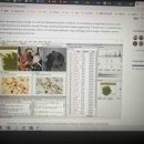
iPyGIRS,(iPy为前缀,说明该软件由作者喜爱的Python开发,GIRS是Geographic Information and Remote Sensing的缩写)是一个以栅格图像处理和机器学习建模为核心功能,集成了数据预处理、图表绘制、张量计算器、样本创建、像元值提取、波段分离、波段计算、图像融合、经验模型建模、方程应用、MySQL数据库管理、GeoServer数据发布等功能的软件。上图是iPyGIRS-V0.2.3-Beta软件的主界面,下图为iPyGIRS未来完工时所具备的功能示意图,目前仅有部分功能。该软件完全基于Python语言(版本3.7.5)开发,可应用于多种遥感监测研究中。目前公开的最新可用版本为V0.2.3-Beta,后续保持持续更新。